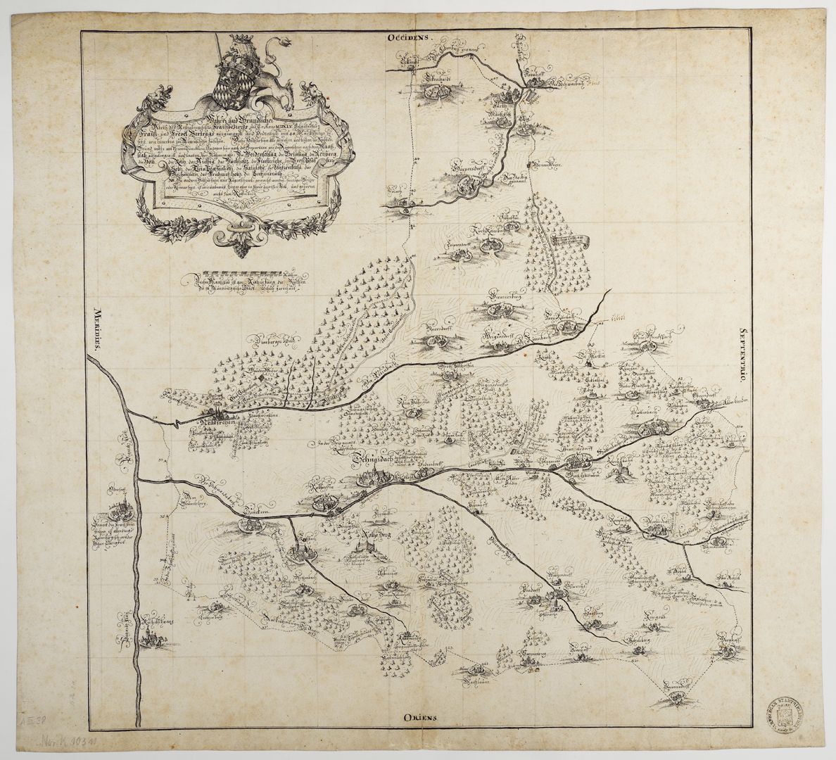
True and thorough outline of the Rottenbergian Frais jurisdictional district (...)
True and thorough outline of the Rottenbergian Frais jurisdictional district (...)
around 1740
True and thorough outline of the Rottenberg Frais district as it was marked out in the year MDXLV according to the Fraiß and Frevel Treaty and properly set with 48 marquee stones, as can be seen here.
________________
Günter Tiggesbäumker, author of the catalogue of the hand-drawn maps and plans of the Nuremberg City Library, writes about the pen drawing: "Topographic map of the time with very beautiful representations of the place in cavalier perspective, but shows the state of the specified area around 1545. The purpose of the map was to precisely define the boundaries of the Rothenberg (Electorate of Bavaria) border with the Nuremberg territory. It is a copy of a map by Hans Trexel from 1634; the pinholes and the grid in pencil as a copying aid can still be seen. The map title is housed in an elaborately designed scrollwork cartouche, crowned by the Bavarian lion and the Electorate of Bavaria coat of arms". Report booklet no. 15 / Friends of the Nuremberg Cultural History Museum Association / Association year 2023 _________________________________ Takeover of the book sponsorship A. III. 38 and the necessary financing of the restoration work carried out in 2023 by the Friends of the Nuremberg Cultural History Museum Association _________________________________
Location: Nuremberg, City Library, inventory number: A. III. 38
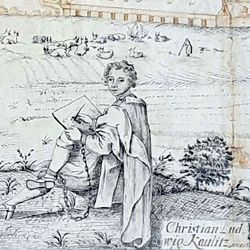
Realization: Kaulitz, Christian Ludwig
Material: Pen drawing on paper, 50.5 x 53 cm
photo 2023,
True and thorough outline of the Rottenbergian Frais jurisdictional district (...)
around 1740
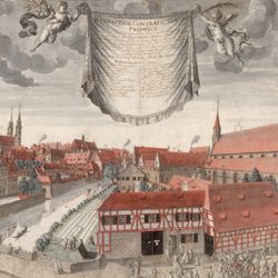
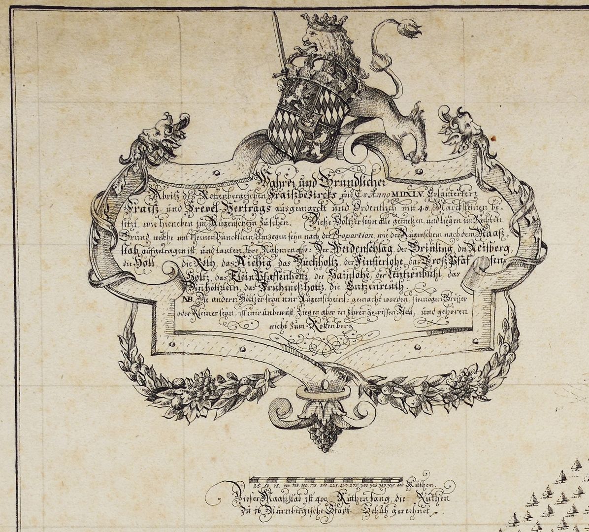
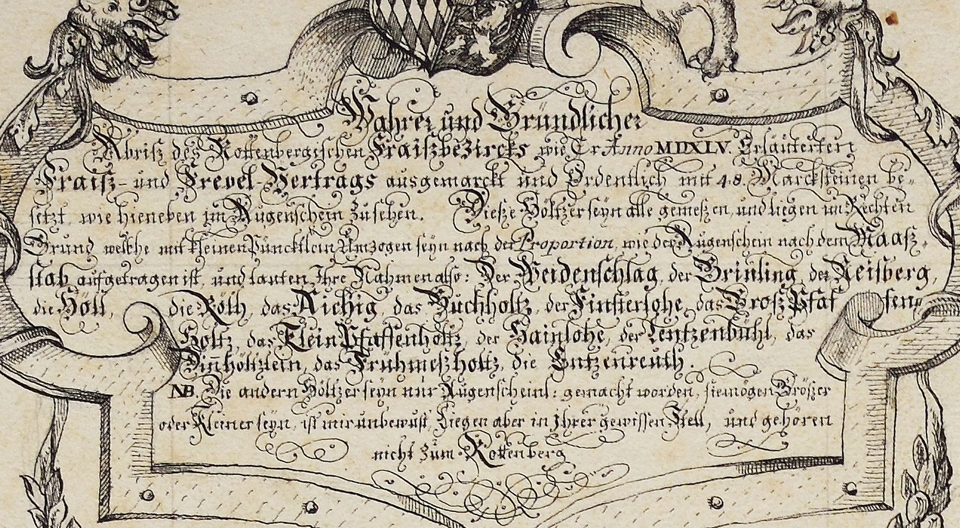
Kartusche mit Inschrift
True and thorough outline of the Rottenberg Frais district as it was marked out in the year MDXLV according to the Fraiß and Frevel Treaty and properly set with 48 marquee stones, as can be seen here.
________________
Günter Tiggesbäumker, author of the catalogue of the hand-drawn maps and plans of the Nuremberg City Library, writes about the pen drawing: "Topographic map of the time with very beautiful representations of the place in cavalier perspective, but shows the state of the specified area around 1545. The purpose of the map was to precisely define the boundaries of the Rothenberg (Electorate of Bavaria) border with the Nuremberg territory. It is a copy of a map by Hans Trexel from 1634; the pinholes and the grid in pencil as a copying aid can still be seen. The map title is housed in an elaborately designed scrollwork cartouche, crowned by the Bavarian lion and the Electorate of Bavaria coat of arms". Report booklet no. 15 / Friends of the Nuremberg Cultural History Museum Association / Association year 2023 _________________________________ Takeover of the book sponsorship A. III. 38 and the necessary financing of the restoration work carried out in 2023 by the Friends of the Nuremberg Cultural History Museum Association _________________________________
Location: Nuremberg, City Library, inventory number: A. III. 38
Realization: Kaulitz, Christian Ludwig
Material: Pen drawing on paper, 50.5 x 53 cm
photo 2023,
True and thorough outline of the Rottenbergian Frais jurisdictional district (...)
around 1740
Inscription
True and thorough outline of the Rottenberg Frais district as it was marked out in the year MDXLV according to the Fraiß and Frevel Treaty and properly set with 48 marquee stones, as can be seen here.
________________
Günter Tiggesbäumker, author of the catalogue of the hand-drawn maps and plans of the Nuremberg City Library, writes about the pen drawing: "Topographic map of the time with very beautiful representations of the place in cavalier perspective, but shows the state of the specified area around 1545. The purpose of the map was to precisely define the boundaries of the Rothenberg (Electorate of Bavaria) border with the Nuremberg territory. It is a copy of a map by Hans Trexel from 1634; the pinholes and the grid in pencil as a copying aid can still be seen. The map title is housed in an elaborately designed scrollwork cartouche, crowned by the Bavarian lion and the Electorate of Bavaria coat of arms". Report booklet no. 15 / Friends of the Nuremberg Cultural History Museum Association / Association year 2023 _________________________________ Takeover of the book sponsorship A. III. 38 and the necessary financing of the restoration work carried out in 2023 by the Friends of the Nuremberg Cultural History Museum Association _________________________________
Location: Nürnberg, Stadtbibliothek, Inventarnummer: A. III. 38
Realization: Kaulitz, Christian Ludwig
Material: Pen drawing on paper, 50.5 x 53 cm
photo 2023,
True and thorough outline of the Rottenbergian Frais jurisdictional district (...)
around 1740
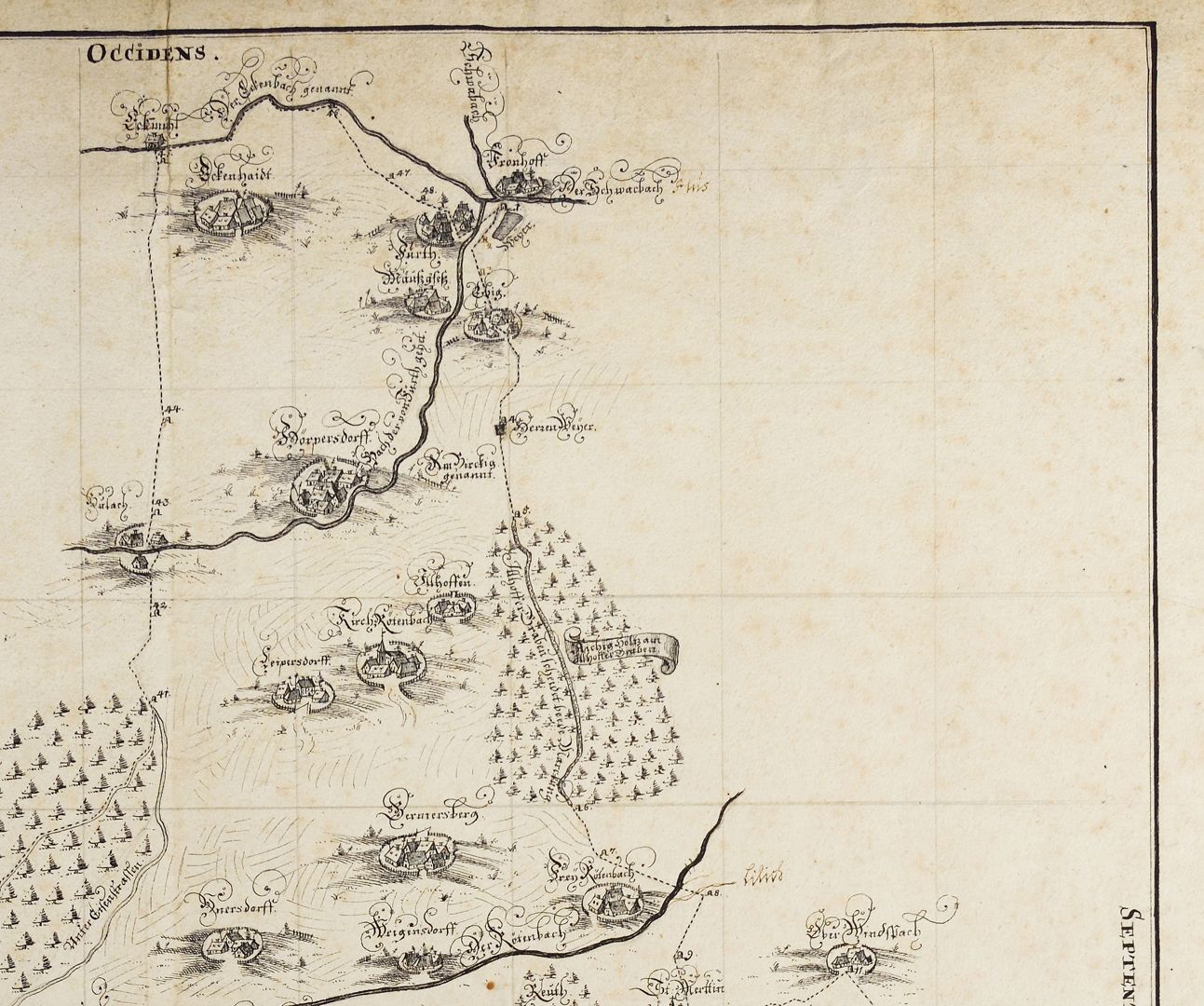
upper right quarter of the map
True and thorough outline of the Rottenberg Frais district as it was marked out in the year MDXLV according to the Fraiß and Frevel Treaty and properly set with 48 marquee stones, as can be seen here.
________________
Günter Tiggesbäumker, author of the catalogue of the hand-drawn maps and plans of the Nuremberg City Library, writes about the pen drawing: "Topographic map of the time with very beautiful representations of the place in cavalier perspective, but shows the state of the specified area around 1545. The purpose of the map was to precisely define the boundaries of the Rothenberg (Electorate of Bavaria) border with the Nuremberg territory. It is a copy of a map by Hans Trexel from 1634; the pinholes and the grid in pencil as a copying aid can still be seen. The map title is housed in an elaborately designed scrollwork cartouche, crowned by the Bavarian lion and the Electorate of Bavaria coat of arms". Report booklet no. 15 / Friends of the Nuremberg Cultural History Museum Association / Association year 2023 _________________________________ Takeover of the book sponsorship A. III. 38 and the necessary financing of the restoration work carried out in 2023 by the Friends of the Nuremberg Cultural History Museum Association _________________________________
Location: Nuremberg, City Library, inventory number: A. III. 38
Realization: Kaulitz, Christian Ludwig
Material: Pen drawing on paper, 50.5 x 53 cm
photo 2023,
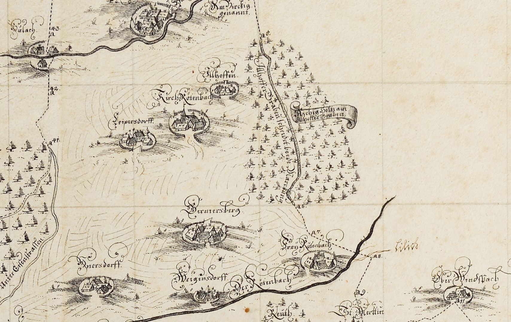
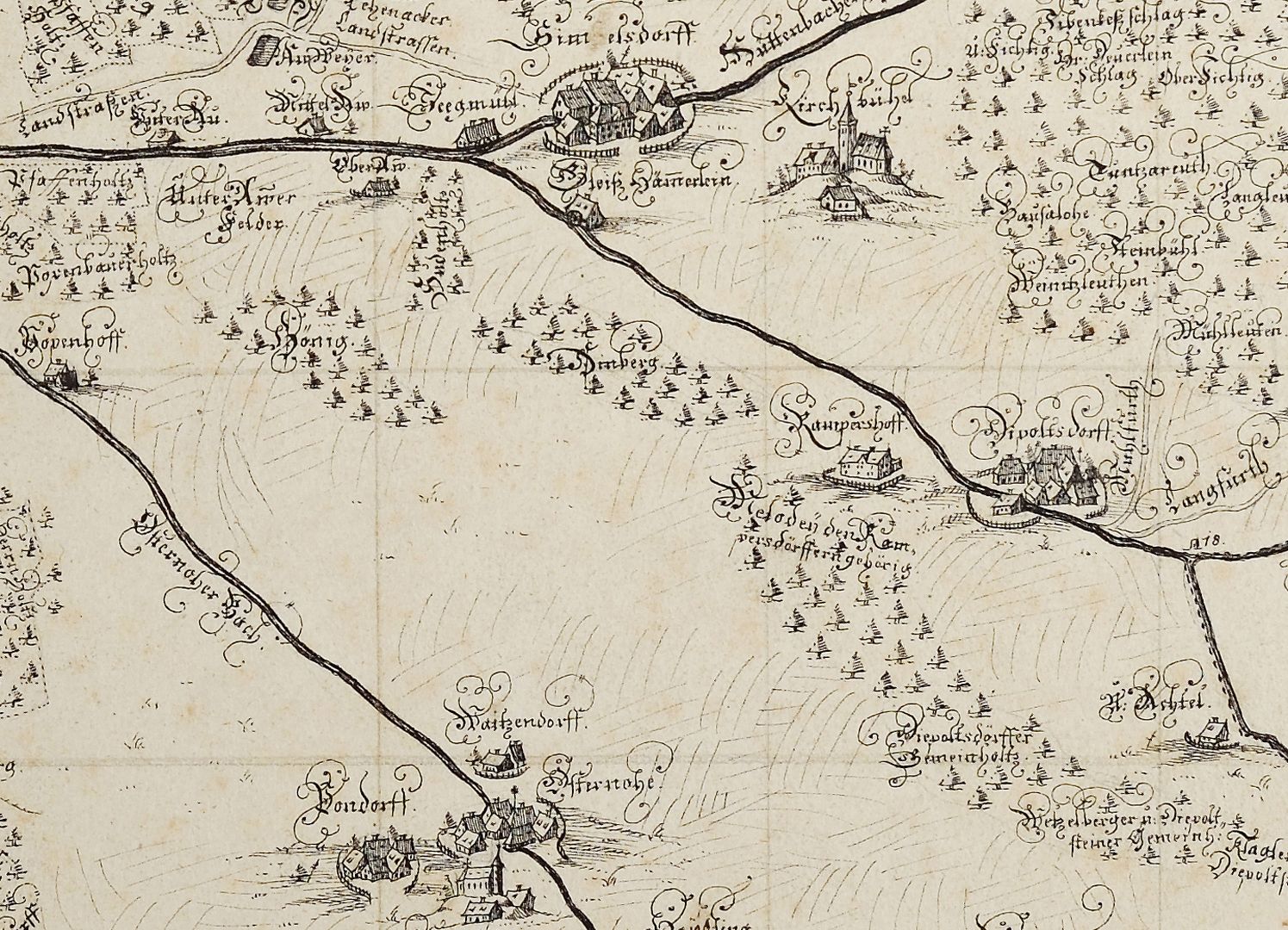
True and thorough outline of the Rottenbergian Frais jurisdictional district (...)
around 1740
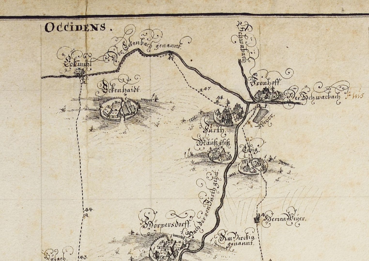
upper right quarter of the map, detailed view
True and thorough outline of the Rottenberg Frais district as it was marked out in the year MDXLV according to the Fraiß and Frevel Treaty and properly set with 48 marquee stones, as can be seen here.
________________
Günter Tiggesbäumker, author of the catalogue of the hand-drawn maps and plans of the Nuremberg City Library, writes about the pen drawing: "Topographic map of the time with very beautiful representations of the place in cavalier perspective, but shows the state of the specified area around 1545. The purpose of the map was to precisely define the boundaries of the Rothenberg (Electorate of Bavaria) border with the Nuremberg territory. It is a copy of a map by Hans Trexel from 1634; the pinholes and the grid in pencil as a copying aid can still be seen. The map title is housed in an elaborately designed scrollwork cartouche, crowned by the Bavarian lion and the Electorate of Bavaria coat of arms". Report booklet no. 15 / Friends of the Nuremberg Cultural History Museum Association / Association year 2023 _________________________________ Takeover of the book sponsorship A. III. 38 and the necessary financing of the restoration work carried out in 2023 by the Friends of the Nuremberg Cultural History Museum Association _________________________________
Location: Nuremberg, City Library, inventory number: A. III. 38
Realization: Kaulitz, Christian Ludwig
Material: Pen drawing on paper, 50.5 x 53 cm
photo 2023,
True and thorough outline of the Rottenbergian Frais jurisdictional district (...)
around 1740
upper right quarter of the map, detailed view
True and thorough outline of the Rottenberg Frais district as it was marked out in the year MDXLV according to the Fraiß and Frevel Treaty and properly set with 48 marquee stones, as can be seen here.
________________
Günter Tiggesbäumker, author of the catalogue of the hand-drawn maps and plans of the Nuremberg City Library, writes about the pen drawing: "Topographic map of the time with very beautiful representations of the place in cavalier perspective, but shows the state of the specified area around 1545. The purpose of the map was to precisely define the boundaries of the Rothenberg (Electorate of Bavaria) border with the Nuremberg territory. It is a copy of a map by Hans Trexel from 1634; the pinholes and the grid in pencil as a copying aid can still be seen. The map title is housed in an elaborately designed scrollwork cartouche, crowned by the Bavarian lion and the Electorate of Bavaria coat of arms". Report booklet no. 15 / Friends of the Nuremberg Cultural History Museum Association / Association year 2023 _________________________________ Takeover of the book sponsorship A. III. 38 and the necessary financing of the restoration work carried out in 2023 by the Friends of the Nuremberg Cultural History Museum Association _________________________________
Location: Nuremberg, City Library, inventory number: A. III. 38
Realization: Kaulitz, Christian Ludwig
Material: Pen drawing on paper, 50.5 x 53 cm
photo 2023,
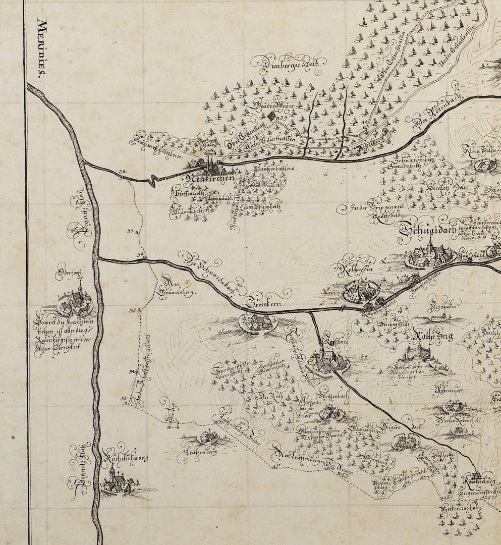
True and thorough outline of the Rottenbergian Frais jurisdictional district (...)
around 1740
lower left quarter of the map
True and thorough outline of the Rottenberg Frais district as it was marked out in the year MDXLV according to the Fraiß and Frevel Treaty and properly set with 48 marquee stones, as can be seen here.
________________
Günter Tiggesbäumker, author of the catalogue of the hand-drawn maps and plans of the Nuremberg City Library, writes about the pen drawing: "Topographic map of the time with very beautiful representations of the place in cavalier perspective, but shows the state of the specified area around 1545. The purpose of the map was to precisely define the boundaries of the Rothenberg (Electorate of Bavaria) border with the Nuremberg territory. It is a copy of a map by Hans Trexel from 1634; the pinholes and the grid in pencil as a copying aid can still be seen. The map title is housed in an elaborately designed scrollwork cartouche, crowned by the Bavarian lion and the Electorate of Bavaria coat of arms". Report booklet no. 15 / Friends of the Nuremberg Cultural History Museum Association / Association year 2023 _________________________________ Takeover of the book sponsorship A. III. 38 and the necessary financing of the restoration work carried out in 2023 by the Friends of the Nuremberg Cultural History Museum Association _________________________________
Location: Nuremberg, City Library, inventory number: A. III. 38
Realization: Kaulitz, Christian Ludwig
Material: Pen drawing on paper, 50.5 x 53 cm
photo 2023,
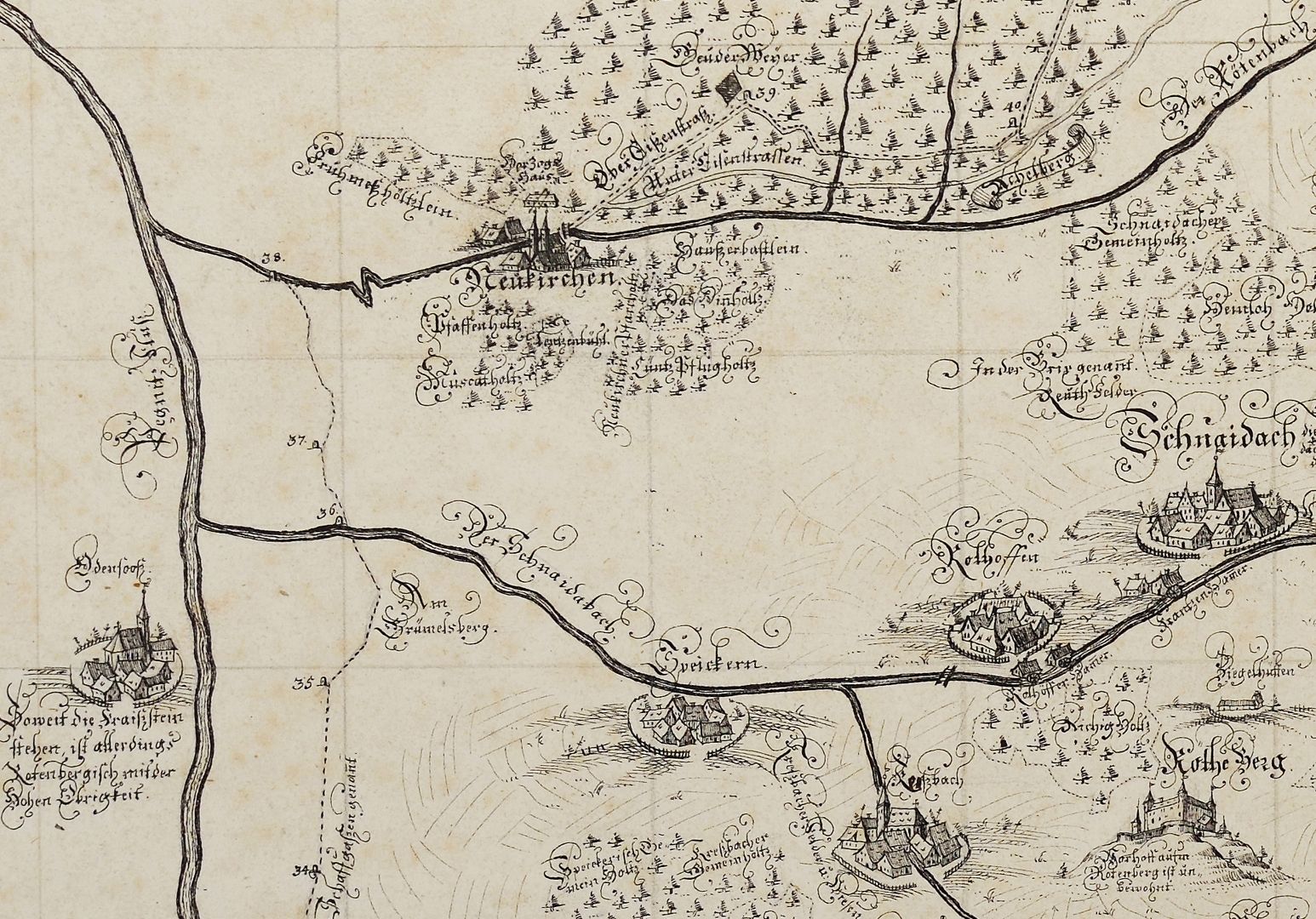
True and thorough outline of the Rottenbergian Frais jurisdictional district (...)
around 1740
lower left quarter of the map, detailed view
True and thorough outline of the Rottenberg Frais district as it was marked out in the year MDXLV according to the Fraiß and Frevel Treaty and properly set with 48 marquee stones, as can be seen here.
________________
Günter Tiggesbäumker, author of the catalogue of the hand-drawn maps and plans of the Nuremberg City Library, writes about the pen drawing: "Topographic map of the time with very beautiful representations of the place in cavalier perspective, but shows the state of the specified area around 1545. The purpose of the map was to precisely define the boundaries of the Rothenberg (Electorate of Bavaria) border with the Nuremberg territory. It is a copy of a map by Hans Trexel from 1634; the pinholes and the grid in pencil as a copying aid can still be seen. The map title is housed in an elaborately designed scrollwork cartouche, crowned by the Bavarian lion and the Electorate of Bavaria coat of arms". Report booklet no. 15 / Friends of the Nuremberg Cultural History Museum Association / Association year 2023 _________________________________ Takeover of the book sponsorship A. III. 38 and the necessary financing of the restoration work carried out in 2023 by the Friends of the Nuremberg Cultural History Museum Association _________________________________
Location: Nuremberg, City Library, inventory number: A. III. 38
Realization: Kaulitz, Christian Ludwig
Material: Pen drawing on paper, 50.5 x 53 cm
photo 2023,
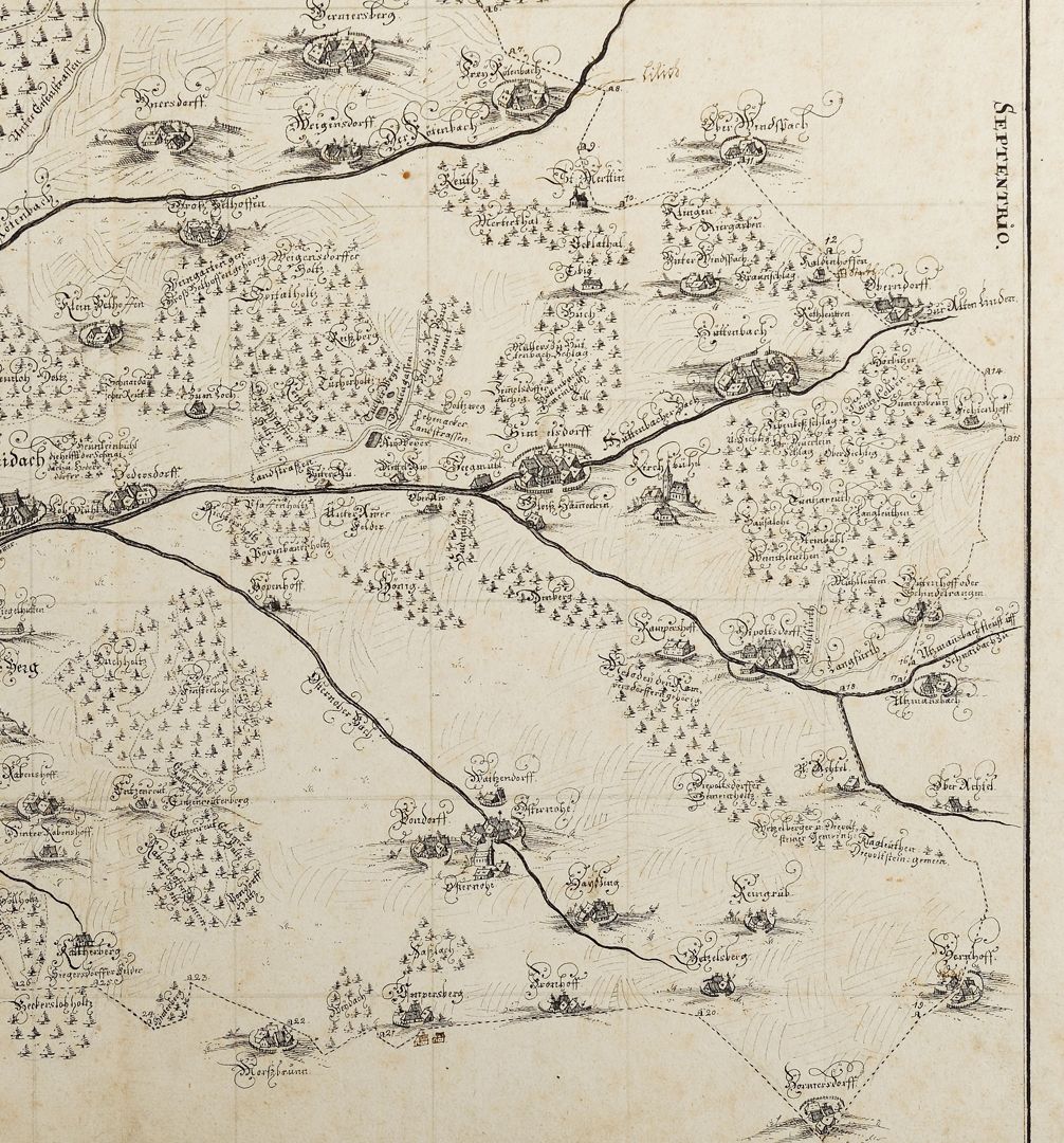
True and thorough outline of the Rottenbergian Frais jurisdictional district (...)
around 1740
lower right quarter of the map
True and thorough outline of the Rottenberg Frais district as it was marked out in the year MDXLV according to the Fraiß and Frevel Treaty and properly set with 48 marquee stones, as can be seen here.
________________
Günter Tiggesbäumker, author of the catalogue of the hand-drawn maps and plans of the Nuremberg City Library, writes about the pen drawing: "Topographic map of the time with very beautiful representations of the place in cavalier perspective, but shows the state of the specified area around 1545. The purpose of the map was to precisely define the boundaries of the Rothenberg (Electorate of Bavaria) border with the Nuremberg territory. It is a copy of a map by Hans Trexel from 1634; the pinholes and the grid in pencil as a copying aid can still be seen. The map title is housed in an elaborately designed scrollwork cartouche, crowned by the Bavarian lion and the Electorate of Bavaria coat of arms". Report booklet no. 15 / Friends of the Nuremberg Cultural History Museum Association / Association year 2023 _________________________________ Takeover of the book sponsorship A. III. 38 and the necessary financing of the restoration work carried out in 2023 by the Friends of the Nuremberg Cultural History Museum Association _________________________________
Location: Nuremberg, City Library, inventory number: A. III. 38
Realization: Kaulitz, Christian Ludwig
Material: Pen drawing on paper, 50.5 x 53 cm
photo 2023,
True and thorough outline of the Rottenbergian Frais jurisdictional district (...)
around 1740
lower right quarter of the map, detailed view
True and thorough outline of the Rottenberg Frais district as it was marked out in the year MDXLV according to the Fraiß and Frevel Treaty and properly set with 48 marquee stones, as can be seen here.
________________
Günter Tiggesbäumker, author of the catalogue of the hand-drawn maps and plans of the Nuremberg City Library, writes about the pen drawing: "Topographic map of the time with very beautiful representations of the place in cavalier perspective, but shows the state of the specified area around 1545. The purpose of the map was to precisely define the boundaries of the Rothenberg (Electorate of Bavaria) border with the Nuremberg territory. It is a copy of a map by Hans Trexel from 1634; the pinholes and the grid in pencil as a copying aid can still be seen. The map title is housed in an elaborately designed scrollwork cartouche, crowned by the Bavarian lion and the Electorate of Bavaria coat of arms". Report booklet no. 15 / Friends of the Nuremberg Cultural History Museum Association / Association year 2023 _________________________________ Takeover of the book sponsorship A. III. 38 and the necessary financing of the restoration work carried out in 2023 by the Friends of the Nuremberg Cultural History Museum Association _________________________________
Location: Nuremberg, City Library, inventory number: A. III. 38
Realization: Kaulitz, Christian Ludwig
Material: Pen drawing on paper, 50.5 x 53 cm
photo 2023,