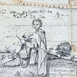
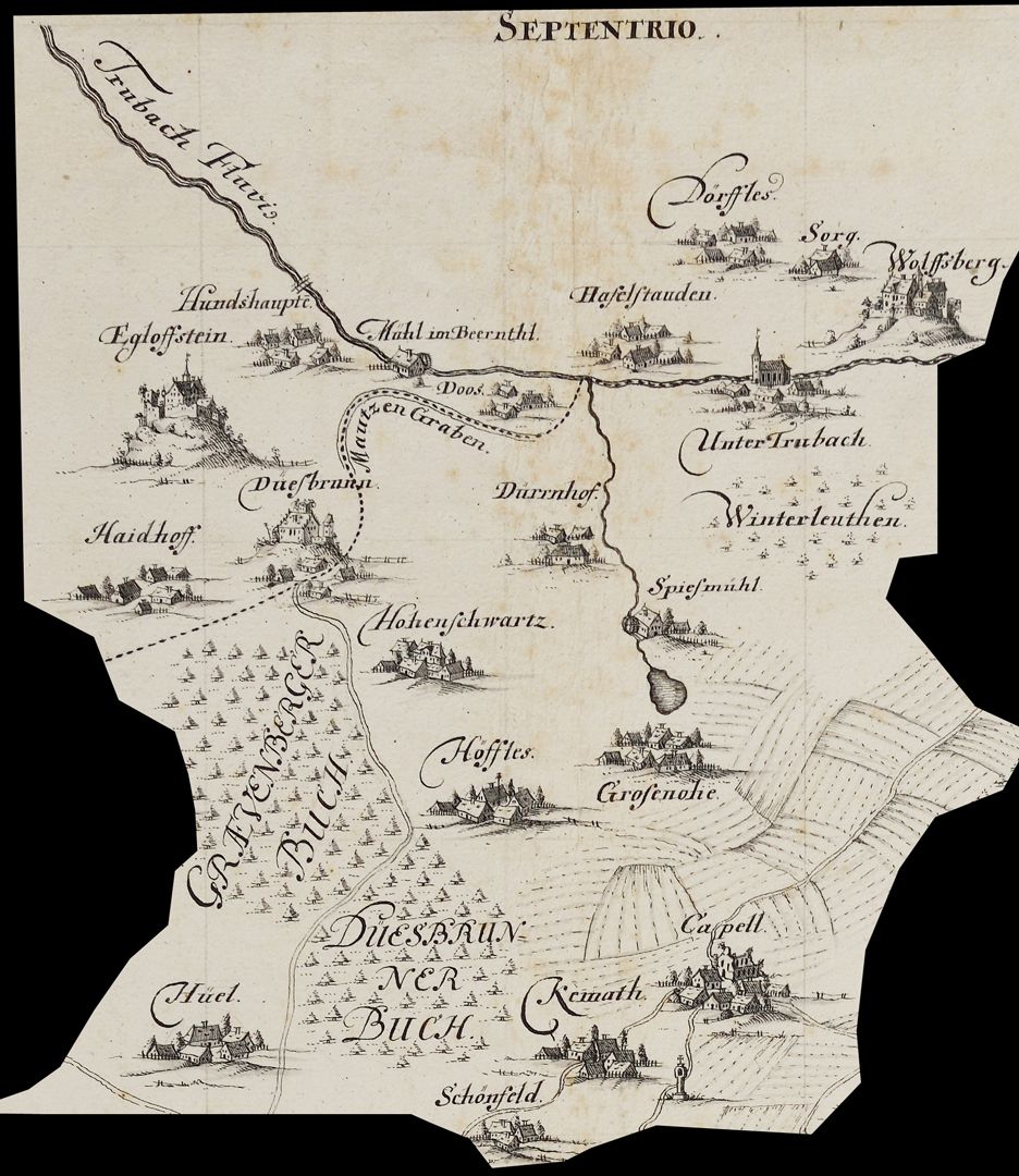
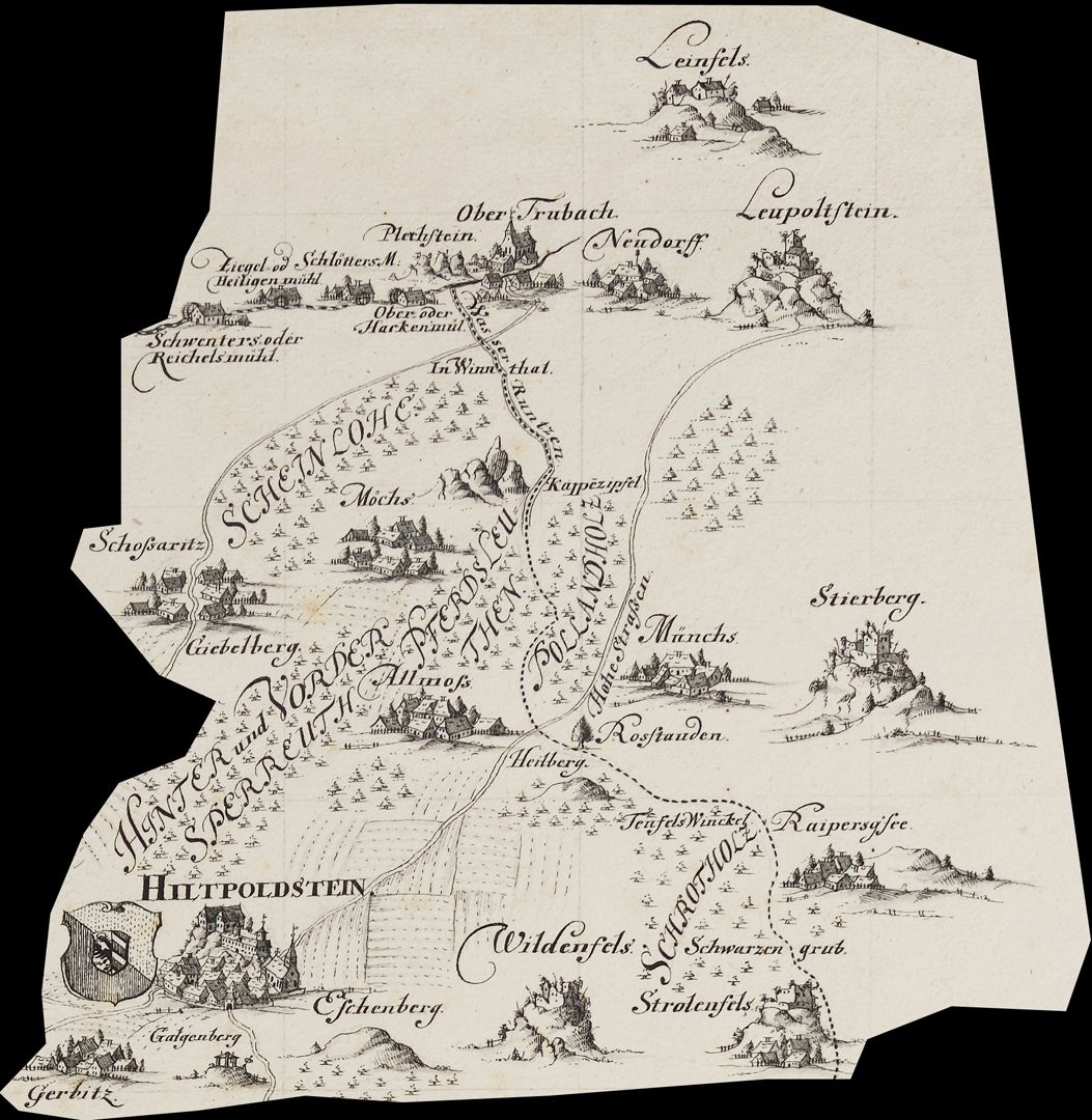
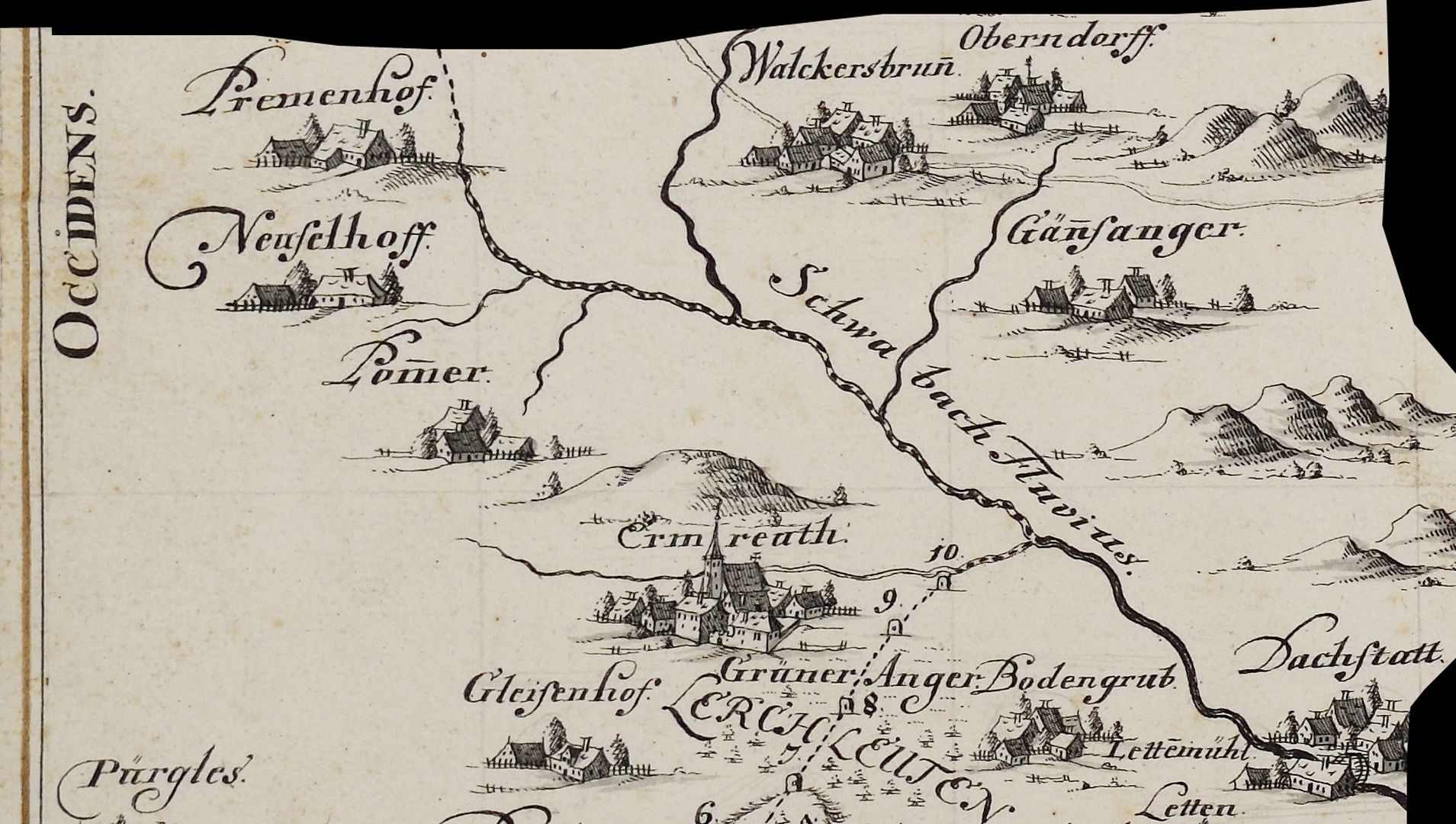
Map of the jurisdictional district Hiltpolstein
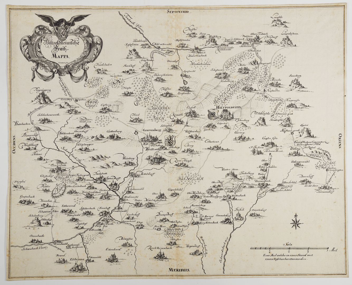
Map of the jurisdictional district Hiltpolstein
around 1740
In his catalog of the hand-drawn maps and plans of the Nuremberg City Library, Günter Tiggesbäumker characterized the Fraisch map (Fraisch = blood jurisdiction) almost exuberantly as follows: "Fraisch map with a petrified border. Situation inside and on the outer edges of the border executed. Settlements in a cavalier manner, topography in a generalization typical of the time. Very high-quality execution, especially the settlements. The latter are works of art in their own right! Elaborate decorative cartouche, ornamental, crowned by the Hersbruck coat of arms, held by an eagle with a sword and scepter. Copy of a map by the Bamberg surveyor Peter Zweidler (around 1603) in the Nuremberg State Archives". Report book no. 15 / Friends of the Nuremberg Cultural History Museum Association / Association year 2023 _________________________________
Takeover of the book sponsorship A. III. 16 and the necessary financing of the restoration work carried out in 2023 by the Friends of the Nuremberg Cultural History Museum Association.
Location: Nuremberg, Stadtbibliothek, inventory number: A. III. 16
Realization: Kaulitz, Christian Ludwig
Material: Pen drawing on paper, 59 x 47.5 cm
photo 2023,
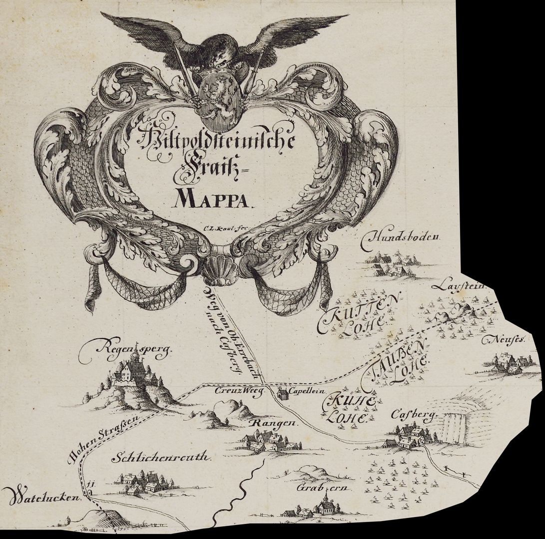
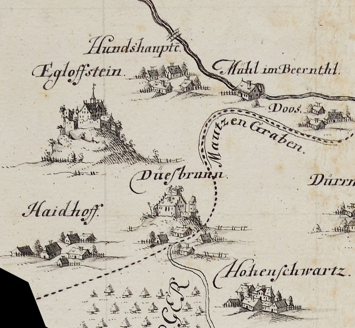
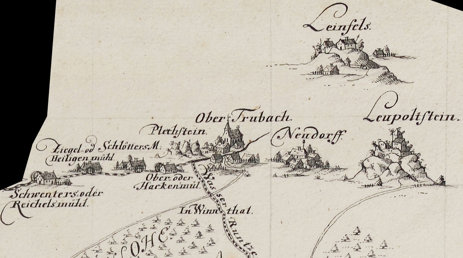
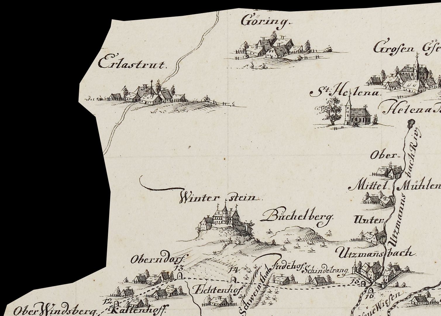
Map of the jurisdictional district Hiltpolstein
around 1740
Image detail left corner of the upper half of the map
In his catalog of the hand-drawn maps and plans of the Nuremberg City Library, Günter Tiggesbäumker characterized the Fraisch map (Fraisch = blood jurisdiction) almost exuberantly as follows: "Fraisch map with a petrified border. Situation inside and on the outer edges of the border executed. Settlements in a cavalier manner, topography in a generalization typical of the time. Very high-quality execution, especially the settlements. The latter are works of art in their own right! Elaborate decorative cartouche, ornamental, crowned by the Hersbruck coat of arms, held by an eagle with a sword and scepter. Copy of a map by the Bamberg surveyor Peter Zweidler (around 1603) in the Nuremberg State Archives". Report book no. 15 / Friends of the Nuremberg Cultural History Museum Association / Association year 2023 _________________________________
Takeover of the book sponsorship A. III. 16 and the necessary financing of the restoration work carried out in 2023 by the Friends of the Nuremberg Cultural History Museum Association.
Location: Nuremberg, Stadtbibliothek, inventory number: A. III. 16
Realization: Kaulitz, Christian Ludwig
Material: Pen drawing on paper, 59 x 47.5 cm
photo 2023,
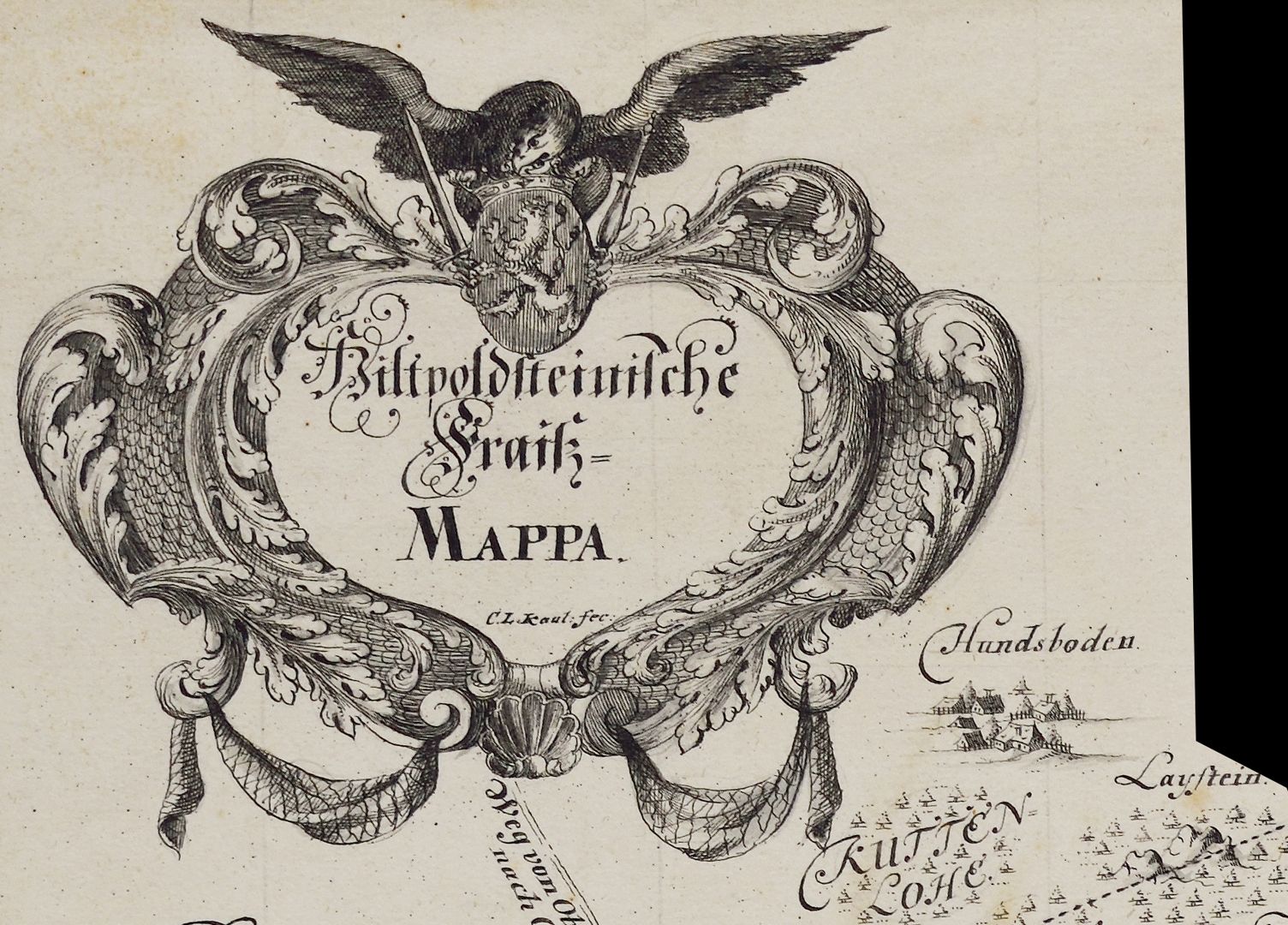
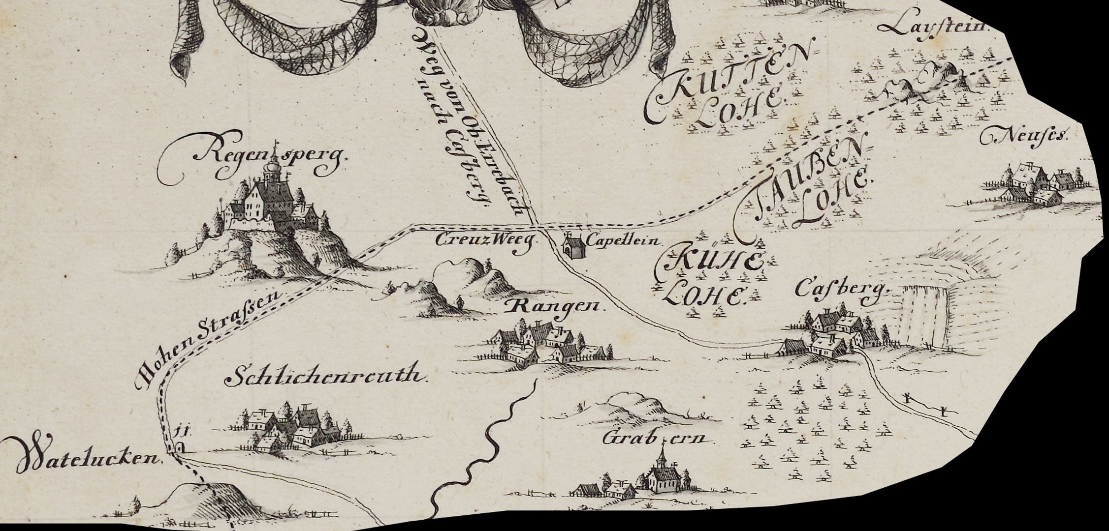
Map of the jurisdictional district Hiltpolstein
around 1740
Bildausschnitt aus der linken Ecke der oberen Kartenhälfte
In his catalog of the hand-drawn maps and plans of the Nuremberg City Library, Günter Tiggesbäumker characterized the Fraisch map (Fraisch = blood jurisdiction) almost exuberantly as follows: "Fraisch map with a petrified border. Situation inside and on the outer edges of the border executed. Settlements in a cavalier manner, topography in a generalization typical of the time. Very high-quality execution, especially the settlements. The latter are works of art in their own right! Elaborate decorative cartouche, ornamental, crowned by the Hersbruck coat of arms, held by an eagle with a sword and scepter. Copy of a map by the Bamberg surveyor Peter Zweidler (around 1603) in the Nuremberg State Archives". Report book no. 15 / Friends of the Nuremberg Cultural History Museum Association / Association year 2023 _________________________________
Takeover of the book sponsorship A. III. 16 and the necessary financing of the restoration work carried out in 2023 by the Friends of the Nuremberg Cultural History Museum Association.
Location: Nuremberg, Stadtbibliothek, inventory number: A. III. 16
Realization: Kaulitz, Christian Ludwig
Material: Pen drawing on paper, 59 x 47.5 cm
photo 2023,
Map of the jurisdictional district Hiltpolstein
around 1740
Image section from the middle of the upper half of the map
In his catalog of the hand-drawn maps and plans of the Nuremberg City Library, Günter Tiggesbäumker characterized the Fraisch map (Fraisch = blood jurisdiction) almost exuberantly as follows: "Fraisch map with a petrified border. Situation inside and on the outer edges of the border executed. Settlements in a cavalier manner, topography in a generalization typical of the time. Very high-quality execution, especially the settlements. The latter are works of art in their own right! Elaborate decorative cartouche, ornamental, crowned by the Hersbruck coat of arms, held by an eagle with a sword and scepter. Copy of a map by the Bamberg surveyor Peter Zweidler (around 1603) in the Nuremberg State Archives". Report book no. 15 / Friends of the Nuremberg Cultural History Museum Association / Association year 2023 _________________________________
Takeover of the book sponsorship A. III. 16 and the necessary financing of the restoration work carried out in 2023 by the Friends of the Nuremberg Cultural History Museum Association.
Location: Nuremberg, Stadtbibliothek, inventory number: A. III. 16
Realization: Kaulitz, Christian Ludwig
Material: Pen drawing on paper, 59 x 47.5 cm
photo 2023,
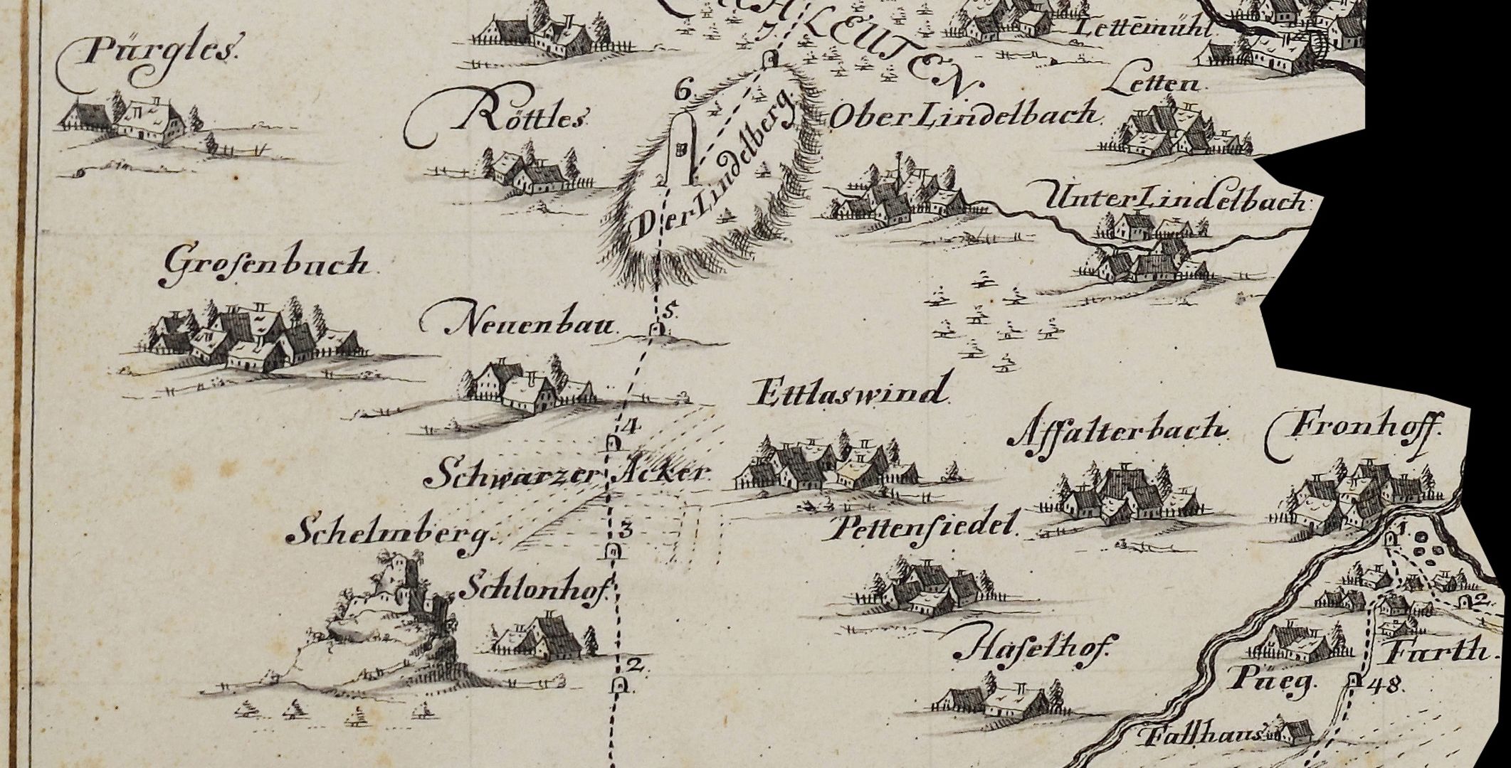
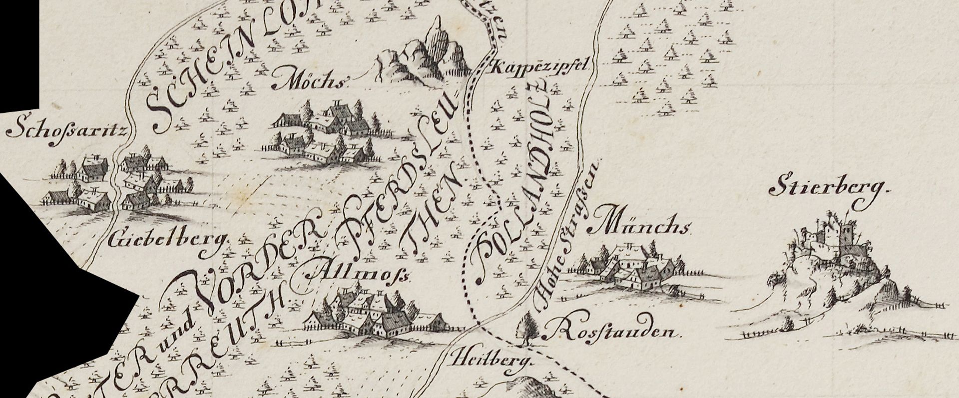
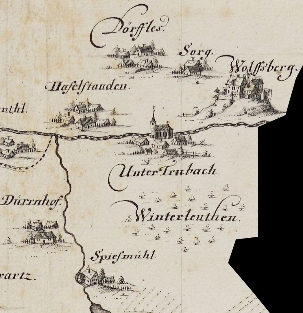
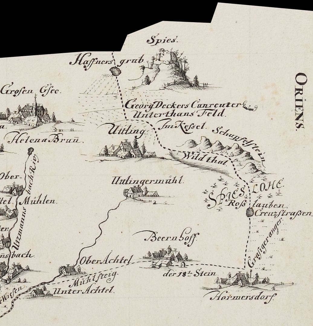
Map of the jurisdictional district Hiltpolstein
around 1740
Image section from the right corner of the upper half of the map
In his catalog of the hand-drawn maps and plans of the Nuremberg City Library, Günter Tiggesbäumker characterized the Fraisch map (Fraisch = blood jurisdiction) almost exuberantly as follows: "Fraisch map with a petrified border. Situation inside and on the outer edges of the border executed. Settlements in a cavalier manner, topography in a generalization typical of the time. Very high-quality execution, especially the settlements. The latter are works of art in their own right! Elaborate decorative cartouche, ornamental, crowned by the Hersbruck coat of arms, held by an eagle with a sword and scepter. Copy of a map by the Bamberg surveyor Peter Zweidler (around 1603) in the Nuremberg State Archives". Report book no. 15 / Friends of the Nuremberg Cultural History Museum Association / Association year 2023 _________________________________
Takeover of the book sponsorship A. III. 16 and the necessary financing of the restoration work carried out in 2023 by the Friends of the Nuremberg Cultural History Museum Association.
Location: Nuremberg, Stadtbibliothek, inventory number: A. III. 16
Realization: Kaulitz, Christian Ludwig
Material: Pen drawing on paper, 59 x 47.5 cm
photo 2023,
Map of the jurisdictional district Hiltpolstein
around 1740
Image section from the right corner of the upper half of the map
photo 2023,
In his catalog of the hand-drawn maps and plans of the Nuremberg City Library, Günter Tiggesbäumker characterized the Fraisch map (Fraisch = blood jurisdiction) almost exuberantly as follows: "Fraisch map with a petrified border. Situation inside and on the outer edges of the border executed. Settlements in a cavalier manner, topography in a generalization typical of the time. Very high-quality execution, especially the settlements. The latter are works of art in their own right! Elaborate decorative cartouche, ornamental, crowned by the Hersbruck coat of arms, held by an eagle with a sword and scepter. Copy of a map by the Bamberg surveyor Peter Zweidler (around 1603) in the Nuremberg State Archives". Report book no. 15 / Friends of the Nuremberg Cultural History Museum Association / Association year 2023 _________________________________
Takeover of the book sponsorship A. III. 16 and the necessary financing of the restoration work carried out in 2023 by the Friends of the Nuremberg Cultural History Museum Association.
Location: Nuremberg, Stadtbibliothek, inventory number: A. III. 16
Realization: Kaulitz, Christian Ludwig
Material: Federzeichnung auf Papier, 59 x 47,5 cm
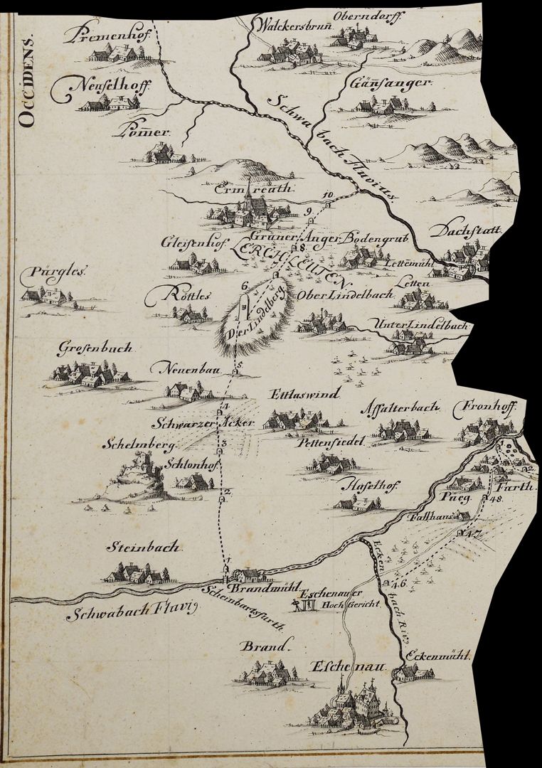
Map of the jurisdictional district Hiltpolstein
around 1740
Image detail of the left corner of the lower half of the map
In his catalog of the hand-drawn maps and plans of the Nuremberg City Library, Günter Tiggesbäumker characterized the Fraisch map (Fraisch = blood jurisdiction) almost exuberantly as follows: "Fraisch map with a petrified border. Situation inside and on the outer edges of the border executed. Settlements in a cavalier manner, topography in a generalization typical of the time. Very high-quality execution, especially the settlements. The latter are works of art in their own right! Elaborate decorative cartouche, ornamental, crowned by the Hersbruck coat of arms, held by an eagle with a sword and scepter. Copy of a map by the Bamberg surveyor Peter Zweidler (around 1603) in the Nuremberg State Archives". Report book no. 15 / Friends of the Nuremberg Cultural History Museum Association / Association year 2023 _________________________________
Takeover of the book sponsorship A. III. 16 and the necessary financing of the restoration work carried out in 2023 by the Friends of the Nuremberg Cultural History Museum Association.
Location: Nuremberg, Stadtbibliothek, inventory number: A. III. 16
Realization: Kaulitz, Christian Ludwig
Material: Pen drawing on paper, 59 x 47.5 cm
photo 2023,
Map of the jurisdictional district Hiltpolstein
around 1740
Image detail of the left corner of the lower half of the map
In his catalog of the hand-drawn maps and plans of the Nuremberg City Library, Günter Tiggesbäumker characterized the Fraisch map (Fraisch = blood jurisdiction) almost exuberantly as follows: "Fraisch map with a petrified border. Situation inside and on the outer edges of the border executed. Settlements in a cavalier manner, topography in a generalization typical of the time. Very high-quality execution, especially the settlements. The latter are works of art in their own right! Elaborate decorative cartouche, ornamental, crowned by the Hersbruck coat of arms, held by an eagle with a sword and scepter. Copy of a map by the Bamberg surveyor Peter Zweidler (around 1603) in the Nuremberg State Archives". Report book no. 15 / Friends of the Nuremberg Cultural History Museum Association / Association year 2023 _________________________________
Takeover of the book sponsorship A. III. 16 and the necessary financing of the restoration work carried out in 2023 by the Friends of the Nuremberg Cultural History Museum Association.
Location: Nuremberg, Stadtbibliothek, inventory number: A. III. 16
Realization: Kaulitz, Christian Ludwig
Material: Pen drawing on paper, 59 x 47.5 cm
photo 2023,
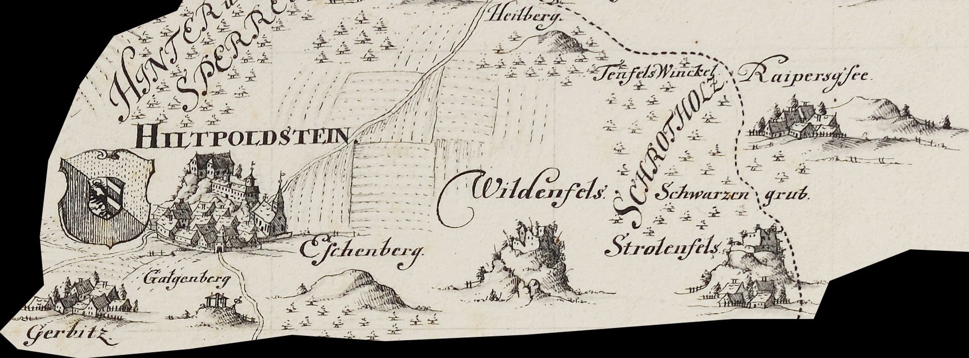
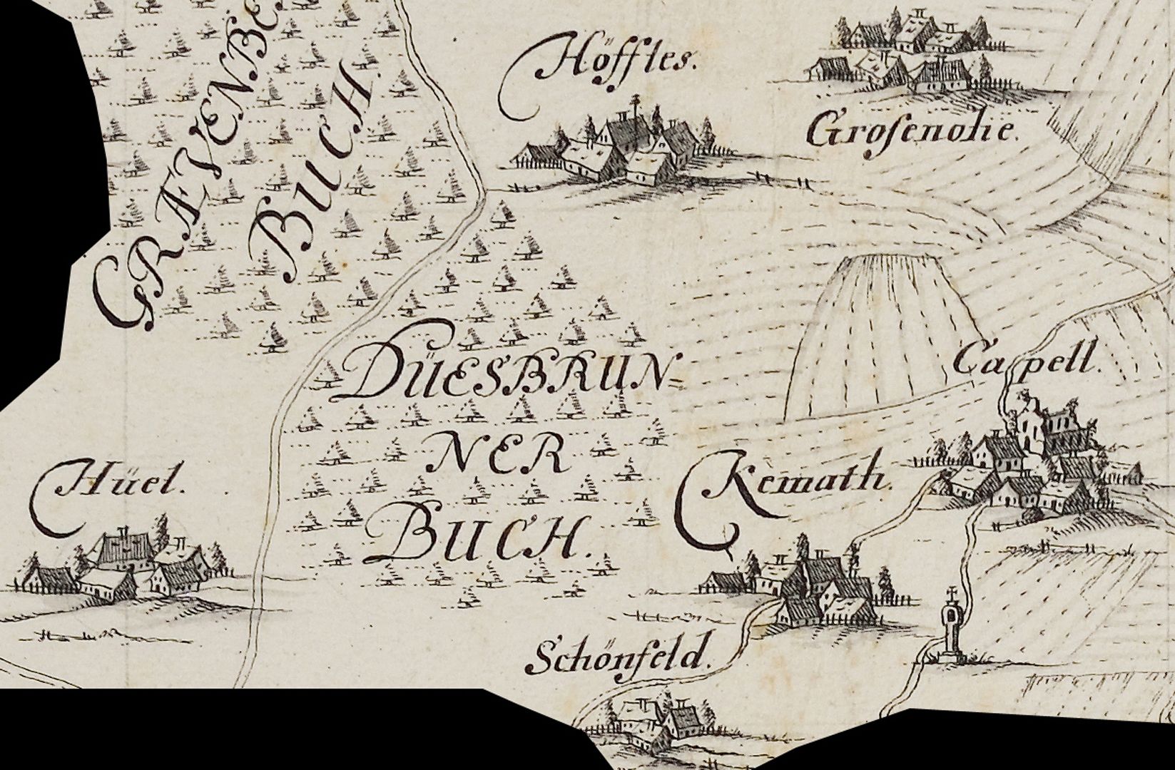
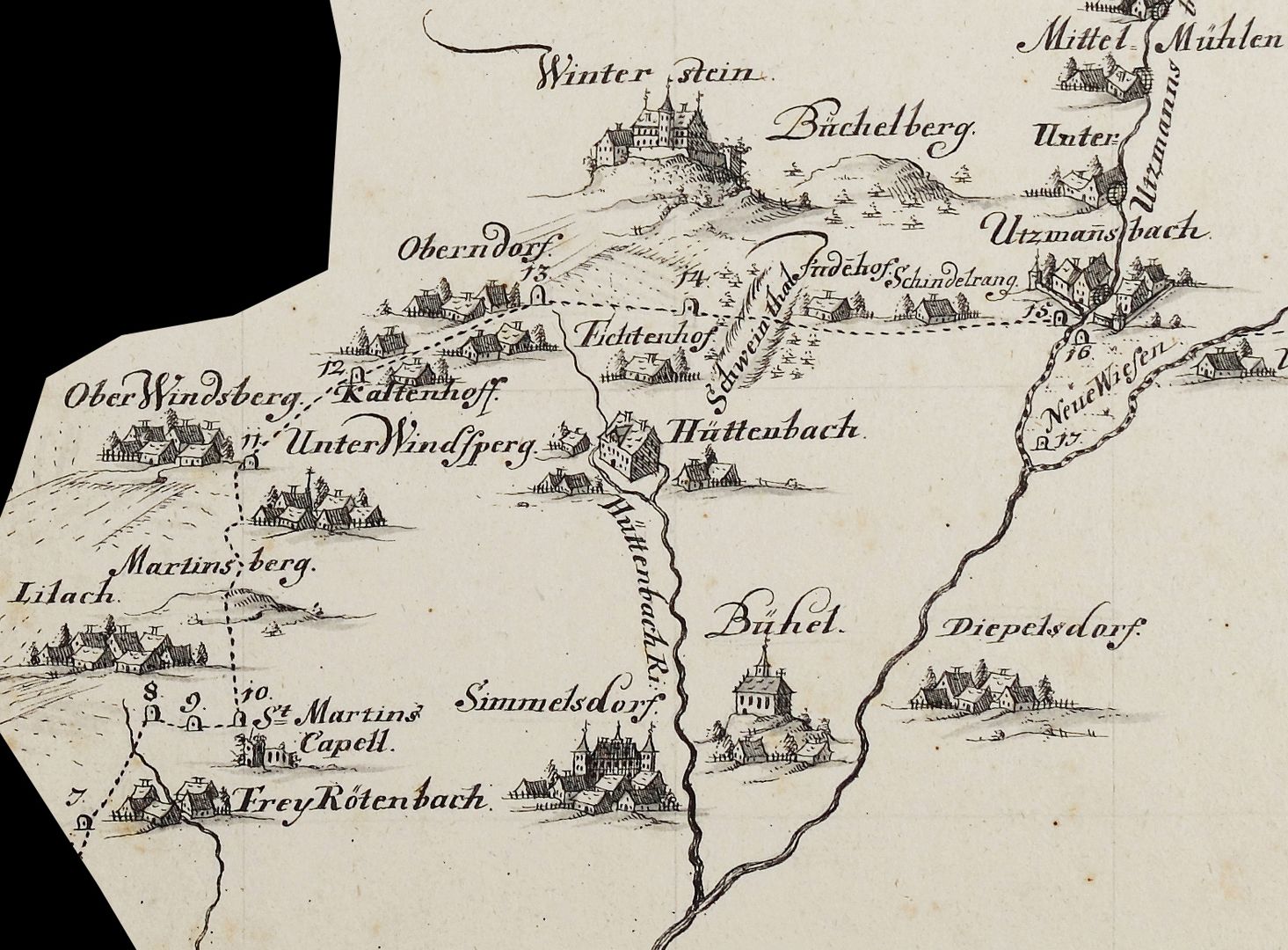
Map of the jurisdictional district Hiltpolstein
around 1740
Image section from the middle of the lower half of the map
In his catalog of the hand-drawn maps and plans of the Nuremberg City Library, Günter Tiggesbäumker characterized the Fraisch map (Fraisch = blood jurisdiction) almost exuberantly as follows: "Fraisch map with a petrified border. Situation inside and on the outer edges of the border executed. Settlements in a cavalier manner, topography in a generalization typical of the time. Very high-quality execution, especially the settlements. The latter are works of art in their own right! Elaborate decorative cartouche, ornamental, crowned by the Hersbruck coat of arms, held by an eagle with a sword and scepter. Copy of a map by the Bamberg surveyor Peter Zweidler (around 1603) in the Nuremberg State Archives". Report book no. 15 / Friends of the Nuremberg Cultural History Museum Association / Association year 2023 _________________________________
Takeover of the book sponsorship A. III. 16 and the necessary financing of the restoration work carried out in 2023 by the Friends of the Nuremberg Cultural History Museum Association.
Location: Nuremberg, Stadtbibliothek, inventory number: A. III. 16
Realization: Kaulitz, Christian Ludwig
Material: Pen drawing on paper, 59 x 47.5 cm
photo 2023,
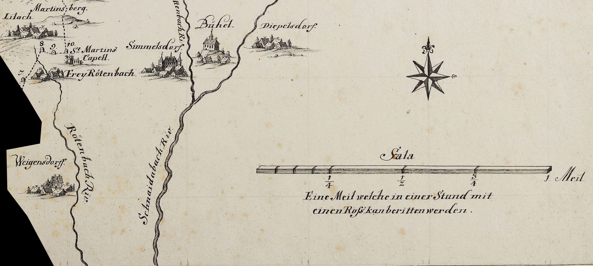
Map of the jurisdictional district Hiltpolstein
around 1740
Image section from the right corner of the lower half of the map
In his catalog of the hand-drawn maps and plans of the Nuremberg City Library, Günter Tiggesbäumker characterized the Fraisch map (Fraisch = blood jurisdiction) almost exuberantly as follows: "Fraisch map with a petrified border. Situation inside and on the outer edges of the border executed. Settlements in a cavalier manner, topography in a generalization typical of the time. Very high-quality execution, especially the settlements. The latter are works of art in their own right! Elaborate decorative cartouche, ornamental, crowned by the Hersbruck coat of arms, held by an eagle with a sword and scepter. Copy of a map by the Bamberg surveyor Peter Zweidler (around 1603) in the Nuremberg State Archives". Report book no. 15 / Friends of the Nuremberg Cultural History Museum Association / Association year 2023 _________________________________
Takeover of the book sponsorship A. III. 16 and the necessary financing of the restoration work carried out in 2023 by the Friends of the Nuremberg Cultural History Museum Association.
Location: Nuremberg, Stadtbibliothek, inventory number: A. III. 16
Realization: Kaulitz, Christian Ludwig
Material: Pen drawing on paper, 59 x 47.5 cm
photo 2023,
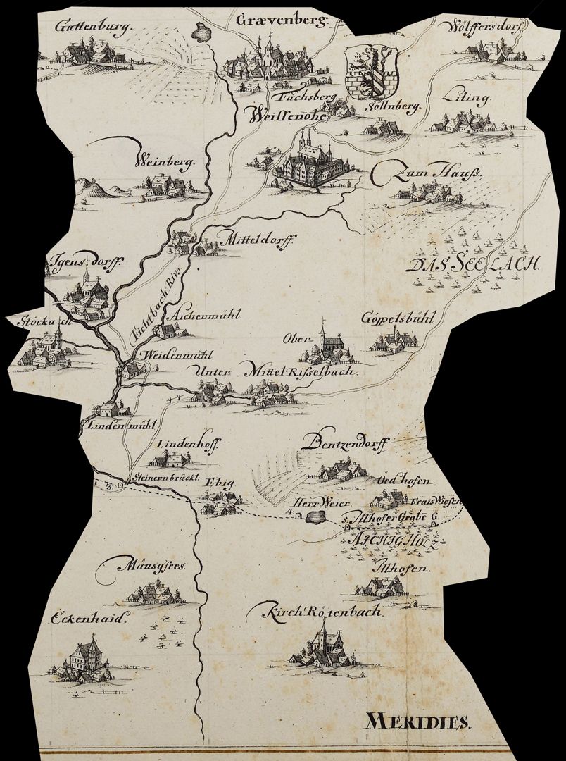
Map of the jurisdictional district Hiltpolstein
around 1740
Image section from the right corner of the lower half of the map
In his catalog of the hand-drawn maps and plans of the Nuremberg City Library, Günter Tiggesbäumker characterized the Fraisch map (Fraisch = blood jurisdiction) almost exuberantly as follows: "Fraisch map with a petrified border. Situation inside and on the outer edges of the border executed. Settlements in a cavalier manner, topography in a generalization typical of the time. Very high-quality execution, especially the settlements. The latter are works of art in their own right! Elaborate decorative cartouche, ornamental, crowned by the Hersbruck coat of arms, held by an eagle with a sword and scepter. Copy of a map by the Bamberg surveyor Peter Zweidler (around 1603) in the Nuremberg State Archives". Report book no. 15 / Friends of the Nuremberg Cultural History Museum Association / Association year 2023 _________________________________
Takeover of the book sponsorship A. III. 16 and the necessary financing of the restoration work carried out in 2023 by the Friends of the Nuremberg Cultural History Museum Association.
Location: Nuremberg, Stadtbibliothek, inventory number: A. III. 16
Realization: Kaulitz, Christian Ludwig
Material: Pen drawing on paper, 59 x 47.5 cm
photo 2023,
Map of the jurisdictional district Hiltpolstein
around 1740
mage section from the right corner of the lower half of the map
In his catalog of the hand-drawn maps and plans of the Nuremberg City Library, Günter Tiggesbäumker characterized the Fraisch map (Fraisch = blood jurisdiction) almost exuberantly as follows: "Fraisch map with a petrified border. Situation inside and on the outer edges of the border executed. Settlements in a cavalier manner, topography in a generalization typical of the time. Very high-quality execution, especially the settlements. The latter are works of art in their own right! Elaborate decorative cartouche, ornamental, crowned by the Hersbruck coat of arms, held by an eagle with a sword and scepter. Copy of a map by the Bamberg surveyor Peter Zweidler (around 1603) in the Nuremberg State Archives". Report book no. 15 / Friends of the Nuremberg Cultural History Museum Association / Association year 2023 _________________________________
Takeover of the book sponsorship A. III. 16 and the necessary financing of the restoration work carried out in 2023 by the Friends of the Nuremberg Cultural History Museum Association.
Location: Nuremberg, Stadtbibliothek, inventory number: A. III. 16
Realization: Kaulitz, Christian Ludwig
Material: Pen drawing on paper, 59 x 47.5 cm
photo 2023,
Map of the jurisdictional district Hiltpolstein
around 1740
Image section from the right corner of the lower half of the map
In his catalog of the hand-drawn maps and plans of the Nuremberg City Library, Günter Tiggesbäumker characterized the Fraisch map (Fraisch = blood jurisdiction) almost exuberantly as follows: "Fraisch map with a petrified border. Situation inside and on the outer edges of the border executed. Settlements in a cavalier manner, topography in a generalization typical of the time. Very high-quality execution, especially the settlements. The latter are works of art in their own right! Elaborate decorative cartouche, ornamental, crowned by the Hersbruck coat of arms, held by an eagle with a sword and scepter. Copy of a map by the Bamberg surveyor Peter Zweidler (around 1603) in the Nuremberg State Archives". Report book no. 15 / Friends of the Nuremberg Cultural History Museum Association / Association year 2023 _________________________________
Takeover of the book sponsorship A. III. 16 and the necessary financing of the restoration work carried out in 2023 by the Friends of the Nuremberg Cultural History Museum Association.
Location: Nuremberg, Stadtbibliothek, inventory number: A. III. 16
Realization: Kaulitz, Christian Ludwig
Material: Pen drawing on paper, 59 x 47.5 cm
photo 2023,
Map of the jurisdictional district Hiltpolstein
around 1740
Image section from the right corner of the lower half of the map
photo 2023,
In his catalog of the hand-drawn maps and plans of the Nuremberg City Library, Günter Tiggesbäumker characterized the Fraisch map (Fraisch = blood jurisdiction) almost exuberantly as follows: "Fraisch map with a petrified border. Situation inside and on the outer edges of the border executed. Settlements in a cavalier manner, topography in a generalization typical of the time. Very high-quality execution, especially the settlements. The latter are works of art in their own right! Elaborate decorative cartouche, ornamental, crowned by the Hersbruck coat of arms, held by an eagle with a sword and scepter. Copy of a map by the Bamberg surveyor Peter Zweidler (around 1603) in the Nuremberg State Archives". Report book no. 15 / Friends of the Nuremberg Cultural History Museum Association / Association year 2023 _________________________________
Takeover of the book sponsorship A. III. 16 and the necessary financing of the restoration work carried out in 2023 by the Friends of the Nuremberg Cultural History Museum Association.
Location: Nuremberg, Stadtbibliothek, inventory number: A. III. 16
Realization: Kaulitz, Christian Ludwig
Material: Federzeichnung auf Papier, 59 x 47,5 cm